Sky Charts
Catalog selection
This panel allows you to select the catalogs you want to use and set
up their properties.
Take a look at the catalog presentation
for more information on the usage of the catalogs
and their content.
Load and Save buttons :
These two buttons allow you to save a particular configuration to a
file and to retrieve it later on.
Stars :
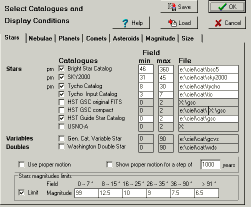
Checkbox : Select or deselect a catalog.
- Catalogs available to generate charts.
- Enter smallest chart width required for the catalog.
- Enter largest chart width required for the catalog.
- Path to the catalog files.
Proper motion : Only the catalogs marked with "pm" have this information.
If the checkbox is marked, the program utilizes the proper motion when
it calculates the position of the object for the current date. It is possible
to display the proper motion by showing the displacement for a period of
1-9999 years in the form of a line.
Star magnitude limits :
Restrict the star visibility to a certain magnitude according to the
chart width.
- Field width range of the chart.
- Magnitude limit.
Nebulae :
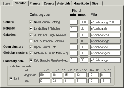
Checkbox : Select or deselect the catalog.
- Catalogs available to generate the charts.
- Smallest field width of chart of the catalog.
- Largest field width of chart of the catalog.
- Path to the catalog files.
Nebulae size limits:
Restrict the nebulae visibility to a certain magnitude according to
the chart width.
- Field width range of the chart.
- Magnitude limit
- Dimension limit in minutes.
Planets :
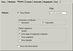
Checkbox : Show or hide the planets.
Path to the files of the planets, comets and asteroids.
Select between geocentric or topocentric position.
Select the drawing type.
See the stars through the planets: this is useful to determine the
end of an occultation.
Comets :
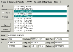
Select one or more comets from the list.
The appearance can be a symbol or a drawing representing the total
magnitude and the size of the coma and the length and direction of the
tail.
You can enter data for a new comet at the bottom of the screen and
save this information in a file by pressing the "save" button.
You can however get this information directly from the Internet with
the option
Online resources.
Asteroids :
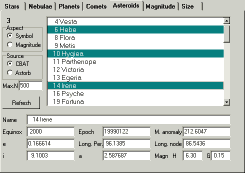
Select one or more asteroids from the list.
The appearance can be a symbol or a drawing representing the total
magnitude.
The list can be obtained from two sources :
- Asteroids : This list can be updated annually from the Internet with the option Online resources.
- Astorb : Edward Bowell, Lowell Observatory The file must be placed in the directory "cat\planet" and it has to be called ASTORB.DAT. Please convert this file in DOS format (cr+lf for EOL). You can also directelly load this file from the Internet with the option Online resources.
External catalog according to the magnitude :
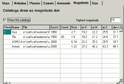
This is the description of the format of a formatted text file subdivided
in columns which is added to the charts if the first column of each entry
is not blank. You can specify the largest magnitude which can be used to
draw the stars.
The general format of the columns is: position.length.
1- This catalogue is active "1" or inactive " ".
2- Catalog name which will be used in the identification
of the object.
3- Complete file path.
4- Epoch of the coordinates.
5- Coordinate type, first character = RA type,
second character = DEC type.
RA type :
0 or blank = Right Ascension in hours.
1 = Right Ascension in degrees.
2 = Right Ascension in radians.
DEC type :
0 or blank = Declination in degrees.
1 = distance from the South pole (SPD)
in degrees.
2 = Declination in radians.
6- Identification name of the object.
7- Right Ascension, hours or decimal Right Ascension.
8- Right Ascension, minutes.
9- Right Ascension, seconds.
10- Sign of the Declination (mandatory if DD MM SS)
11- Declination, degrees or decimal Declination.
12- Declination, minutes.
13- Declination, seconds.
14- Magnitude.
15- Color index B-V.
16,17,18- Description or supplementary information.
Several examples can be found in default.opt.
External catalog according to the size :
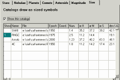
This is the description of the format of a formatted text file subdivided
in columns which is added to the charts if the first column of each entry
is not blank.
The general format of the columns is: position.length.
1- This catalogue is active "1" or inactive " ".
2- Catalog name which will be used in the identification
of the object.
3- Complete file path.
4- Epoch of the coordinates.
5- Coordinate type, first character = RA type,
second character = DEC type.
RA type :
0 or blank = Right Ascension in hours.
1 = Right Ascension in degrees.
2 = Right Ascension in radians.
DEC type :
0 or blank = Declination in degrees.
1 = distance from the South pole (SPD)
in degrees.
2 = Declination in radians.
6- Identification name of the object.
7- Right Ascension, hours or decimal Right Ascension.
8- Right Ascension, minutes.
9- Right Ascension, seconds.
10- Sign of the Declination (mandatory if DD MM SS)
11- Declination, degrees or decimal Declination.
12- Declination, minutes.
13- Declination, seconds.
14- Magnitude.
15- Color index B-V
16,17,18- Description or supplementary information.
19- Color, a constant value which corresponds to
the colour defined
for the stars.
20- Symbol shape, constant value.
1 : circle.
2 : square.
3 : diamond.
21- Blank=linear scale, 1=logarithmic scale.
(useful if the size has to represent the intensity,
i.e. in the
case of radio sources).
Warning!
Most of the catalogs available on CD-ROM or from the Internet, as well
as Astorb.dat, are in UNIX format (thus end of line = LF). It is important
to convert them to DOS format (thus end of line = CR+LF) before you use
them with "Sky Charts" as external catalogs. There are several programs
and utilities to accomplish this task. Amongst them the editor
PFE
or the TLF utility.
Images
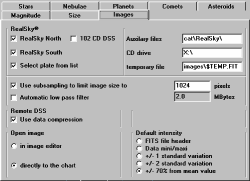
Images loading options.
Realsky options:
- Select available CD's (North, South, 102 CD).
- Select plate form a list of available plates or automaticaly select
the best centered plate.
- Path where you install the support files.
- CD drive path or path where you copy the RealSky files.
- File name for the temporary FITS file used for extraction.
- Using subsampling to automaticaly limit the temporary file size to
a reasonable value.
- Automaticaly apply a low pass filter to limit the compression effect
to the sky background.
Remote DSS options:
- Use Gzip compression to download the image file. This reduce the
file size by a factor two or three .
Open Image options:
- To the image editing tool to modify some parameters or directely
to the chart.
- Select default intensity range values used to display the image.